Lake Oroville Community Update - June 2
Lake Oroville Community Update - June 2
Lake Oroville Water Operations
The Department of Water Resources (DWR) continues to make releases from Lake Oroville using the main spillway at Oroville Dam. Ongoing releases ensure continued storage space in Lake Oroville for spring runoff from snowmelt and are closely coordinated with the U.S. Army Corps of Engineers and downstream water operators.
Total releases to the Feather River amount to 4,000 cubic feet per second (cfs) with 2,200 cfs being routed down the low-flow channel which flows through the City of Oroville. An additional 1,800 cfs is being released from the Thermalito Afterbay River Outlet, located 5 miles downstream from Oroville.
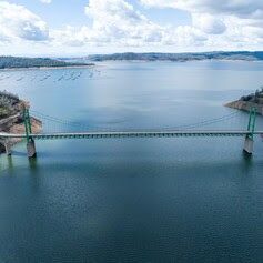
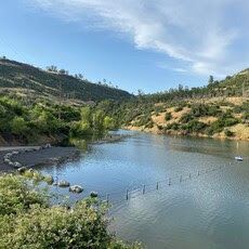
Since Dec. 1, Lake Oroville’s storage has increased more than 230 feet and gained over 2.4 million acre-feet of water. Lake Oroville is currently at 98 percent capacity and is expected to reach full capacity this month. As Oroville reaches full capacity there will be the potential for some waves to splash over the crest of the emergency spillway if we experience any particularly windy days. While unlikely, DWR will be monitoring for the potential of any wave runup that might splash over the crest of the emergency spillway. Wave splash will not affect the integrity of the emergency spillway structure or Oroville Dam.
Visitors to Oroville Dam may also notice minor amounts of water flowing from drains built into the emergency spillway. As the reservoir level has increased, water flow from the drains has increased, which is normal and expected with the emergency spillway design. The dam and emergency spillway continue to operate as intended.
Driftwood and other floating debris on Lake Oroville are expected due to continued water inflows from tributaries and a high lake level, in combination with past wildfires impacting the watershed. Since January, State officials and marina partners have been collecting, containing, and pulling pieces of wood out of the lake and away from boat launch ramps using boom lines. However, boaters, water skiers, and other water recreationists should take precautions when operating boats on Lake Oroville and should remain alert for floating debris.
The Lake Oroville reservoir is the largest storage facility in the State Water Project (SWP) and supports environmental and water delivery needs to 27 million Californians and reduces flood risks to downstream communities. DWR continues to closely monitor lake levels and will adjust releases accordingly to optimize operations for water storage and environmental protection while allowing for carryover storage into next year.
Thermalito Forebay Vegetation Management
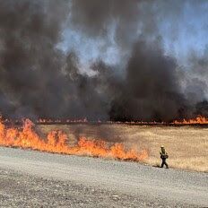
For the third straight year, DWR, CAL FIRE/Butte County Fire Department, and the California Department of Parks and Recreation (State Parks) will conduct a series of prescribed burns around the Thermalito Forebay. The targeted two-week window for this project is June 3 to June 17 and depends on favorable weather conditions.
The Forebay Vegetation Management Project (VMP) was first conducted in 2021 to improve valley grassland and vernal pool habitat. Invasive annual grasses and other invasive species like the yellow star thistle degrade native grasslands and fire is a valuable tool to combat this degradation. Because invasive species have seeds and dry material called thatch that build up on the soil, it is important to burn the same area multiple years in a row. When completed during the right stage in these species' growth cycle, the control burns eradicate the current crop, reduce the dry residual thatch, and decreases the spread of seeds. The area has seen a significant decline in the volume of invasive grasses and star thistles since the project began. The project burns also allow DWR to continue post-fire studies on vernal pool habitat.
CAL FIRE/Butte County Fire Department will also be conducting prescribed burns near the Rabe Road Shooting Range during this period. Smoke from the control burns will be highly visible in the Oroville area.
Car-Top Boat Launches
State Parks has closed the Nelson Bar Car-Top Boat Launch due to high lake water levels that have inundated the parking lot, which is at an elevation between 891 to 895 feet. The parking lot and car-top launch ramp will reopen again once Lake Oroville water levels recede.
High water levels have also permitted the Vinton Gulch Car-Top Boat Launch to reopen. The car-top boat launch may be accessed via State Route 70 and Cherokee Road along the west branch of the north fork arm of Lake Oroville.
Walk Into Wellness
Join State Parks for a series of guided, meditative walks around the Lake Oroville State Recreation Area that promote health and wellness. These free walks focus on calming reflections and enlightening exercises while immersed in the beauty of nature. Sturdy shoes and a water bottle are recommended for participants. Wellness walks are scheduled from 8 a.m. to 10 a.m. on the following dates and locations:
- Saturday, June 10: Loafer Creek; meet at the Loafer Creek Day Use Area
- Sunday, July 16: Bidwell Canyon; meet at the Toll House Museum
Oroville Recreation
The Lake Oroville Visitor Center is open Monday through Friday between 9 a.m. and 5 p.m. The Visitor Center offers numerous educational exhibits, a theater featuring videos about the building of Oroville Dam, and a 47-foot-tall observation tower providing unsurpassed panoramic views.
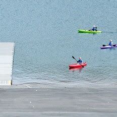
DWR, State Parks, and CDFW maintain over 92 miles of trails in the Oroville area. An interactive map of recreation facilities, including open boat ramps, and their permitted uses is available on DWR’s Lake Oroville Recreation webpage. A paper trail map is available at various locations, including most entrance kiosks and the Visitor Center. The marinas at Bidwell Canyon and Lime Saddle are open daily and provide a variety of services such as a shuttle and boat rentals.
Current Lake Operations
Lake Oroville is at 895 feet elevation and storage is approximately 3.47 million acre-feet (MAF), which is 98 percent of its total capacity and 123 percent of the historical average.
The Feather River releases are at 4,000 cubic feet per second (cfs). Flows through the City of Oroville are 2,200 cfs with 1,800 cfs released from the Thermalito Afterbay Outlet (Outlet) for a total of 4,000 cfs downstream of the Outlet. DWR continues to assess releases to the Feather River daily.
The public can track precipitation, snow, reservoir levels, and more at the California Data Exchange Center. The Lake Oroville gage station is identified as “ORO”.
All data as of midnight 6/2/2023.